
The Airport Master Record (AMR) and You
Wait…what’s an AMR?
As pilots, we should become as familiar as possible with the airports that we plan to visit.
How long are the runways? Can I buy fuel? Is the pavement in good condition?
All of these questions and many more can be answered by reviewing the Airport Master Record or AMR prior to your trip.
As a self-proclaimed airport nerd, I like to know as much as possible about the airports that I plan to fly to. And as a pilot who tries to plan trips carefully, I don’t like surprises, so part of my trip planning normally includes gathering data about my destination airports. Sure, I check for NOTAMS at the airport and along the route of flight, but I also like to review the details of the development at the airport, things like how many runways are available, their orientation, types of fuel available, what NAVAIDS can I expect and any other special items I should know about. If I think that I might be hungry when I arrive, the most important question to ask is will I be eating at a restaurant or out of a vending machine? Unfortunately the AMR doesn’t always provide information for hunger planning.

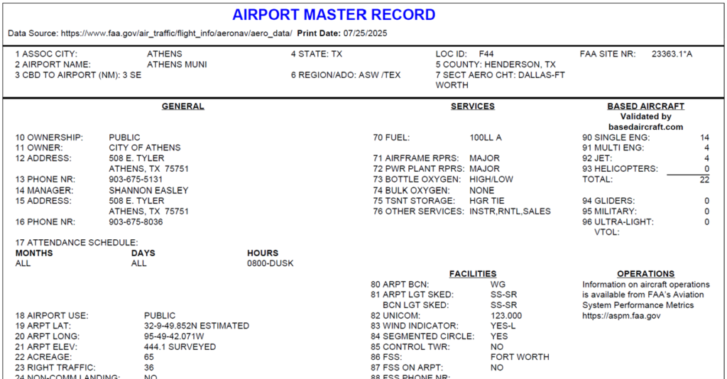
A helpful tool that I like to review for each airport is the AMR, you may also hear this document called the 5010 form. This is a standard record that is available for many airports in the United States and includes both open to the public airports as well as many privately owned airfields. The FAA has an Advisory Circular 150/5300-19 and an associated data dictionary that explains the various fields in this record and what each abbreviation means.
You can get a lot of this information from Foreflight or your on-board GPS, however, those devices and services get most of their information from the FAA databases, including the AMR. So, by looking directly at the AMR you are getting the data straight from the horse’s mouth, or at least straight from the FAA’s internet tubes.
Plus, worst case scenario, if your GPS goes down or you forgot to pay for your Foreflight subscription, the AMR could be quite handy to have.
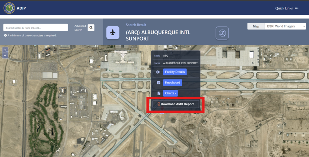
To start off, you can view and download the AMR from the FAA’s Airport Data and Information Portal or ADIP for short.
Once on the ADIP website, enter the airport LOCID, then when the airport aerial photo appears, you can hover over the airplane icon in the middle of the aerial photo then click on the “Download AMR Report” link to view it or save it.
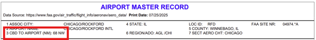
The AMR is divided into several sections and each item has a number and a data label. For example, item #1 is the airport’s associated city. Keep in mind that the associated city may not always be apparent to you as many airports near larger cities like to use the larger city first then use a slash to enter the actual city or town where the airport is located. An interesting example of this is the Chicago/Rockford International Airport (RFD) which is actually located in the city of Rockford, Illinois, 68 nautical miles northwest of Chicago. Based on that distance from the “associated city” they could have also called the airport the “Southern Greater Oconomowoc Regional Jetport” or S-GORJ, that doesn’t sound very appealing.
Sometimes airports like to use the associated city as a marketing tool rather than a geographic fact so be aware of that ploy, er, I mean perfectly allowable and suitable practice.
Speaking of the relative location of an airport to the associated city, Item #3 in the AMR is labelled “CBD to airport”.
Wait, wait, did you say “CBD”? Are we talking about that CBD found in certain gummy bears and pain relief creams?
No, this form isn’t talking about “that” CBD, this CBD refers to the central business district. So, in our earlier example of Rockford, it is listed as 68 nautical miles northwest, so this means that the airport is 68 nautical miles northwest of the Chicago central business district. This item on the AMR can be especially helpful when you are flying into an unfamiliar airport at night, you at least have a good idea of where the airport is supposed to be in relation to the city it’s serving.
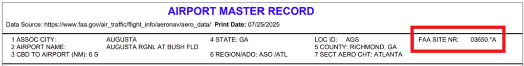
Also in the upper right portion of the AMR is the FAA Site number, you don’t really need to worry about this because the number itself won’t mean much to you. However, at the end of the number is a letter of the alphabet that corresponds to the type of facility you are looking at.
A=Airport
B=Balloon port
C=Seaplane Base
G=Glider port
H=Heliport
U=Ultra-light Flight Park
V=Vertiport (On Hold) although some of these are in the early development stages
You can also discern some helpful information just by the length of the airport LOCID. Private use airports normally have 4 characters while public use facilities normally have 3 characters. I say “normally” because there are some occasions where an airport may change their use years after originally opening and the FAA doesn’t like to change LOCIDs because they are considered permanent once assigned. These instances are fairly rare though. Almost as rare as a greaser landing from me.
If the airport has a website, it is also listed near the top of the AMR. I’m surprised because a lot of airports have not entered their websites on the AMR but you may find a few who have.
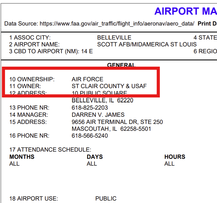
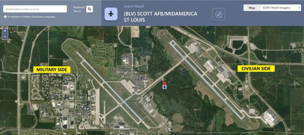
Item #10 identifies the airport ownership as military, private or public. Unless you want to be greeted by a pair of F-16’s, you’ll want to make sure you’re heading to the right type of airport. This is especially true in certain parts of the country where military airfields are located quite close to civilian airports. If you ever spend time flying in the mid-Atlantic region, you will experience this issue quite often. You’ll also want to use special care when flying into a joint use facility which is both military and civilian. A fun example of this setup is Scott Air Force Base/Midamerica Airport in Belleville, Illinois (BLV). Essentially the west half of the airport is military while the east half is civilian with a 1 ¼ mile long taxiway between the two sides.
Item #17 details the airport attendance schedule. For me, I usually like to arrive at airports during their normal attendance times, I know that’s not true for everyone and circumstances may not always allow it. I just like to know that if I’m landing at an unfamiliar airport and I have an issue, either with my plane or my bladder, that there will be someone there to point me in the right direction. Be on the lookout here for seasonal attendance schedules and the dates for when those start. There are also some airports that charge a fee if you need after hours service so keep that in mind as well.
Item #18 shows whether the airport is open to the public or is private use only. A public-use airport is an airport available for use by the general public without a requirement for prior approval from the owner or operator. A private-use airport is an airport available for use by the owner only or by the owner and other persons authorized by the owner only.
Item #21 shows the airport elevation above mean sea level (ASML). But just exactly what point on the airport are we talking about here? Some airports are flat as a table top while others have quite a gradient from one end to the other. The precise definition of the airport elevation is a point that is measured along the centerline at the highest point of the airport’s usable runways.
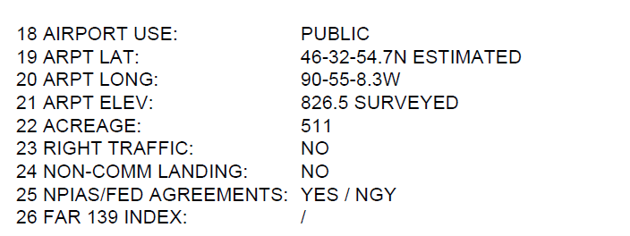
Item #23 identifies if any of the runways have right hand traffic patterns. Right hand patterns are most often required due to conflicting traffic patterns with nearby airports or for terrain avoidance.
In these days of ever increasing costs, Item #24 may be the most important data label on the entire AMR – Non-commercial landing fee. I’ll be honest, if this field says ‘Yes’, there is a high probability that I’m not landing there. I have this same type of visceral reaction when I have to take a toll road with my vehicle as well. The exception that I have is that if I know the airport will be a fuel stop and the landing fee is waived with a fuel purchase. Flying is expensive enough and yes, maybe I can be called frugal, OK, maybe I could be called a cheapskate but I don’t want to spend any more than I have to on a trip.

Not every airport does a great job of explaining their landing fees, particularly when the fee only applies to larger aircraft or aircraft over a certain weight. Sometimes those more detailed explanations can be found in Item #110 which is the Remarks section which we will cover in more detail later.
Item #26 identifies if the airport is a FAR Part 139 certificated airport. In general, Part 139 airports are those airports that have commercial airline service, this isn’t always the case though as some airports who used to have airline service continue to maintain their Part 139 certificate. Airports with a Part 139 certificate are normally inspected on a regular basis by the FAA. What this means for you is that a Part 139 airport will have aircraft firefighting equipment and personnel available and there could be additional helpful signage and pavement marking available. So if you happen to have a nosewheel fall off while in flight or your gear won’t come down properly, it may be a good idea to find a Part 139 airport to land at. In theory, Part 139 airports are also inspected more frequently than non-Part 139 airports so if you have concerns about pavement conditions or foreign object debris or FOD, using a Part 139 airport may be advantageous for you. However, most non-Part 139 airports are maintained to excellent standards.
Items 30 through 63 give details on the runways or helipads that are available at the airport. Let’s take a closer look at some of these items and what you may need to be on the lookout for when using the airport.
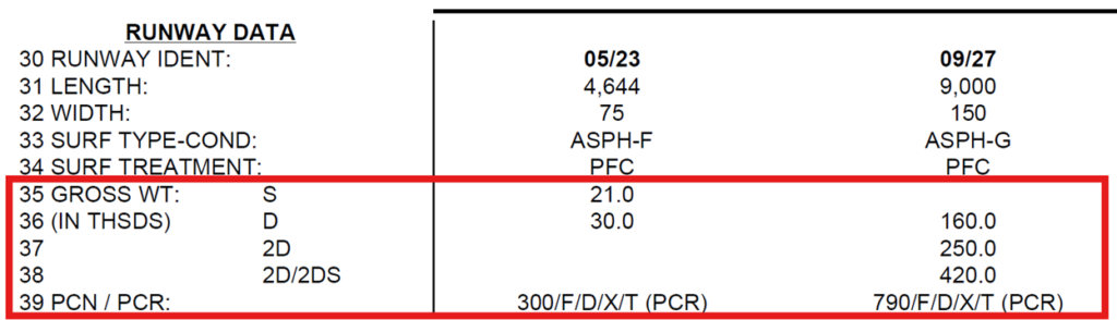
Item #31 seems simple enough as it lists the runway length to the nearest foot. However, what is not noted here are any displaced thresholds or declared distances which are identified in items 51 and 60 through 63. Long story short, a 5,000 foot runway listed in this item may not mean that all 5,000 feet of the runway is usable for all operations in each direction.
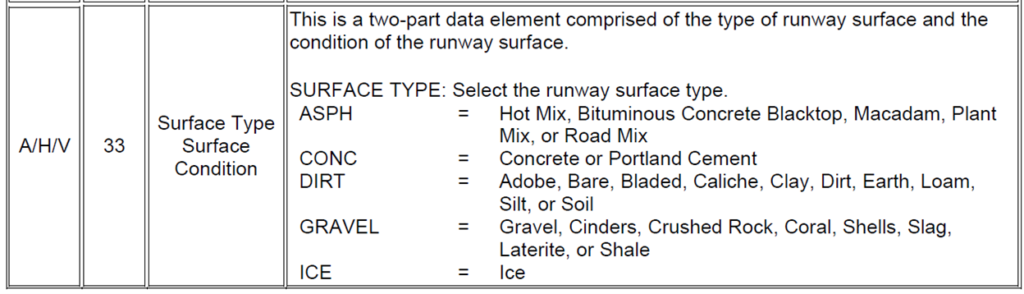
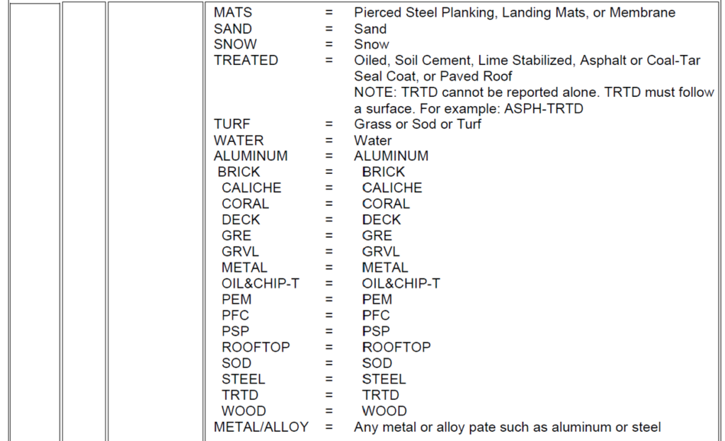
Item #33 provides the runway surface type and condition. For most of my flying in the midwest, the two main types of pavement have been asphalt or concrete with an occasional turf surface so I’ve had quite the pampered flying life. However, the AMR allows 13 different types of surfaces, plus there can be any combination of those surfaces. My favorite surface type listed in the AMR is “Aluminum”.
The surface condition ranges from excellent to failed. Just a quick word of advice, I’ve seen some failed pavements and you do not want to land on or take off from a failed pavement with standard landing gear. Maybe you could get by with a tundra tire setup but failed pavement in general is bad news for airplanes. The other concern with failed and even some poor pavements is the potential for Foreign Object Debris or FOD. And no, when I say foreign object, I’m not referring to a croissant or a Canada goose, I’m talking about chunks of pavement. FOD has a nasty habit of nicking up propellers and can be quite devastating to jet engines.
Items #35 to #39 identify the aircraft weights that the runway pavements are intended to support. These pavement strength numbers are not hard and fast limits, what I mean by that is if the single wheel pavement strength is listed as 12,500 pounds, an airplane weighing 13,000 pounds probably will not immediately destroy the pavement upon landing. However, if your airplane is well above the pavement strength listed in the AMR, it is probably a good idea to land on a different runway or a different airport with stronger pavement. Many times the apron pavement strength is similar to the runway pavement strength so that is an important factor if you decide to park your King Air on an apron designed to handle 4,000 pound aircraft on a hot summer day. I have seen a few larger aircraft sink into some asphalt apron pavement during the hot summer months, let’s just say it wasn’t a fun or easy exercise to haul the aircraft out of the pavement holes they created.
Item #40 lists the type of runway lighting. There are 3 main types of runway edge lighting, low intensity, medium and high. Normally medium or high intensity lights are required when the airport has instrument approaches available. This item will also identify if the lighting system is non-standard. This statement means that the lighting system may not meet FAA standards for light intensity or spacing so for these runways, the lighting may not look like what you are used to seeing. I would be wary of any runway lighting setup that mentions “Lighting temporarily relocated to village Christmas tree”.
Item #43 details the type of visual glideslope indicator that is available for each end. The types we are most familiar with would be some sort of VASI or PAPI. This data label actually has 23 different types available but it largely just distinguishes between the type of equipment (the most typical is P for PAPI and V for VASI) plus the number of light boxes for each. For certain pieces of equipment, this data field will also show which side of the runway it is on.
Item #45 shows the visual glide angle into the runway end. The standard angle is 3 degrees which equates to 1 foot of vertical descent for every 19 feet of horizontal travel. If you see an angle greater than 3 degrees, then you know that the approach will be a bit steeper than you may be accustomed to flying.
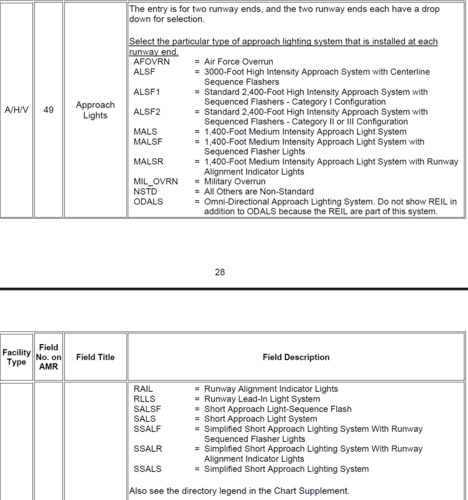
Item #49 lists any approach lighting systems that are available. These systems are usually what sends a tired pilot’s heart leaping for joy after a strenuous IFR approach. Each of these approach light systems have their own characteristics and layout which we will talk about in a future article.
Item #51 indicates if there is a displaced threshold on a particular runway. This can be of importance when operating on those runways of marginal length because the displaced threshold will reduce that landing length available even further. In many cases, though not all, the displaced threshold is due to some sort of big stick in the ground in the runway approach.
This big stick could be an actual stick like a tree, or something like an antenna, a building, a mountain, or Victor Wembanyama being in the vicinity if you are landing near San Antonio. The actual obstruction items and more details are identified in Items #52 through #58 to give you an idea of what it is and how close it is to the runway end.
Items #60 through #63 discuss if the runway utilizes declared distances which can be a complicated subject so we will cover this in greater detail in a future article.
Moving on from runway information, item #70 details the types of fuel that are available, ranging from 100LL to Jet-A and MOGAS and several other types in between.
Then items #71 and #72 show if there are airframe or engine repairs available on the field. Now, I know that we never leave on a trip expecting to need repairs, but this is something to keep in mind as it’s always handy to have a mechanic available on the airport.
Items #90 through #105 detail the number of based aircraft and the number of operations at the airport. The FAA is currently transitioning the operations data out of the AMR and out of ADIP.
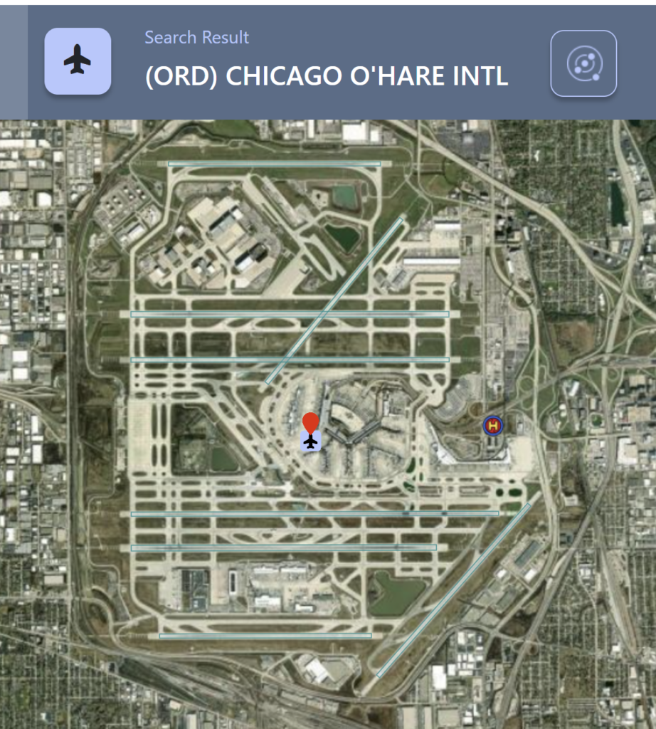
For points of reference, O’Hare International Airport (ORD) has about 750,000 annual operations, this equates to about 2,055 operations per day.
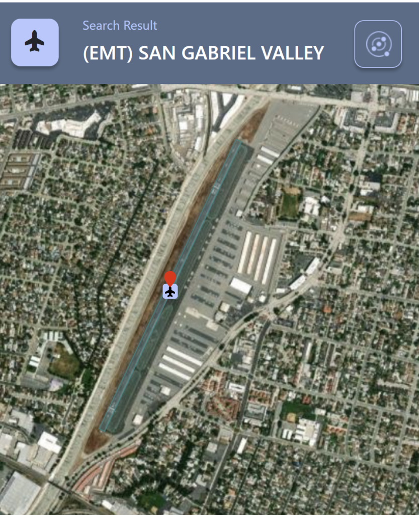
A busy reliever type airport like San Gabriel Valley (EMT) near Los Angeles has about 88,000 annual operations or about 241 operations per day.
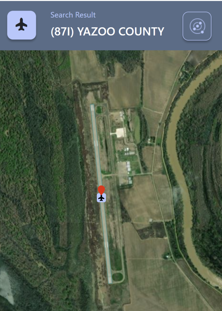
And a smaller, rural general aviation facility like Yazoo County (87I) near Yazoo City, Mississippi has about 8,600 annual operations or about 23 operations per day.
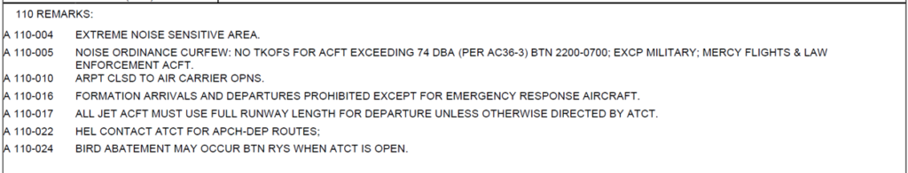
And finally, Item #110 at the bottom of the AMR is the remarks section. The remarks section is available for the airport owner to identify other pertinent information that may not be captured in the previous standard data labels. For some airports, the remarks section is incredibly important and can go on for several pages. I recommend reviewing these remarks thoroughly because they can identify unique practices or characteristics at a certain airport.
For example at Van Nuys airport in California (VNY), the remarks extend the AMR to four pages, largely due to their noise abatement procedures. At some airports, those noise abatement procedures aren’t just for the big guys either, in some instances they apply to single engine Cessna’s and Piper’s as well.
That’s about it for the AMR form itself, however, the ADIP website also has many additional features that we’ll get into in a future article.